![]() Lake Malawi has been over fished for many years. RIPPLE Africa is now working with Communities on a fish conservation project. Local bylaws have been signed and the communities are now empowered to manage their fish stocks sustainably.
Lake Malawi has been over fished for many years. RIPPLE Africa is now working with Communities on a fish conservation project. Local bylaws have been signed and the communities are now empowered to manage their fish stocks sustainably.
Sep 142013
![]() Lake Malawi has been over fished for many years. RIPPLE Africa is now working with Communities on a fish conservation project. Local bylaws have been signed and the communities are now empowered to manage their fish stocks sustainably.
Lake Malawi has been over fished for many years. RIPPLE Africa is now working with Communities on a fish conservation project. Local bylaws have been signed and the communities are now empowered to manage their fish stocks sustainably.
![]() Original story by Jano Gibson, ABC News
Original story by Jano Gibson, ABC News

Free-flowing bore. Claims that irrigators are racing to secure valuable water licences before they run out. Image: ABC TV
Four applications were advertised this week, seeking a total of 15.7 billion litres of water from the Ooloo aquifer, which feeds the Daly River.
Environment Centre director Stuart Blanch says that would increase the current allocations of water by 60 per cent.
He says irrigators are racing to secure valuable water licences in the Katherine region, about 300 kilometres south of Darwin, before they run out.
"This is a harbinger of what's to come, with a massive northern food bowl push," he said.
"I think a lot of fishermen, traditional owners, river communities downstream and environmentalists will say the Daly is coming under increasing pressure from water extraction.
"It's a race to get whatever water they can for free.
"People, I think, are ignoring the concern of scientists, people living downstream who use the healthy river, and they just want to get in before they lose out."
Sandalwood supplier TFS has applied for a extraction licences of 13 billion litres from the southern and northern sections of the Ooloo aquifer.
Earlier this year, there was controversy when an application to draw up to 5.8 gigalitres of water a year was granted to Stylo Station near Mataranka, about 100 kilometres south of Katherine, from the Tindall aquifer.
The Tindall aquifer feeds the Roper River.
The Stylo Station licence is by far the largest in the area.
The property is owned by the family of Country Liberals federal election candidate Tina MacFarlane, who is now waiting for the results of counting of the final votes for the seat of Lingiari.
Labor's Warren Snowdon remains marginally ahead.
The MacFarlanes say they want to use the water for irrigation.
Original story by John Elder, Sydney Morning Herald

In need of help: The Great Barrier Reef. Photo: AP
At a speed-dating night for nerds, the talk isn't about love or even real estate investment - it's all about finding new friends with which to team up and save the world.
At such a night in Edinburgh, deep-sea biologist Lea-Anne Henry had 60 seconds to connect with artificial intelligence wizard David Corne.
''I said 'I need to find some way to get a robotics system down to repair our coral reefs.' He said, 'I have a solution to that.' ''
Professor Corne, from the School of Mathematical and Computer Sciences at Heriot-Watt University, was working in ''swarm intelligence'', an emerging technology where robots in large numbers work in a coordinated fashion.
Dr Henry, speaking from Edinburgh, says: ''He suggested a swarm of robots could rebuild the reefs, working like ants or bees, in the way they rebuild a nest.''
From that conversation 18 months ago, Coralbots - a project dedicated to making Corne's vision come true - was born. The team includes a computer vision scientist, and engineers who had already been working with underwater robots doing repair work for the petroleum industry. ''We're working to adapt those robots for our mission,'' says Henry.

The buzz: Computer scientists are developing coralbot robots to repair and rebuild coral reefs.
The robots would basically scavenge fragments of dead coral, pile these up to make a base for a new reef, and then hunt down fragments of live coral to pile on top.
''One challenge is to make sure the robots grippers (hands) don't crush the coral … we haven't got that far yet,'' says Henry.
For the past year or so, using a large library of images, the team has been training the computer software to recognise corals - dead and living fragments - and distinguish them from sponges and rocks, with a 75 per cent success rate so far.
''We've also been working on making sure the robots don't crash into the coral,'' says Henry. ''And we have to train them to hover which is proving tricky. Robots have a terrible time hovering.''
Britain has deep-sea cold-water reefs that aren't as pretty as tropical reefs, but do the same work of protecting coastal areas from violent seas and sediment build-up, and supporting large ecosystems. The British reefs are routinely damaged by bottom-trawling and fishing.
The initial testing of the coralbots, however, will take place off the coast of Belize, which is home to the second largest coral reef in the world, after Australia's reef. ''We need to run a proof-of-concept exercise in shallow water before dropping these things into deep water.''
The group recently received a large grant from the UK government to fund equipment, but Coralbots is also taking the online crowd-funding route - via the Kickstarter platform - to pay for testing and development. Donors are rewarded with recognition ($15 gets your name on a coralbot) and T-shirts.
Could coralbots help save the Great Barrier Reef? ''It would take us 15 years to get the project up to that scale,'' says Henry.
Whether or not our reef can wait 15 years is another question.
Original story at Port Douglas News Daily
A floating raft of pumice created by an underwater volcanic eruption near New Zealand, and teeming with marine hitchhikers, has been spotted in the northern Great Barrier Reef.

Wayne Fox with a havre pumice.
Rafts of porous volcanic rock are a remarkable, but poorly understood, natural phenomenon which play a unique role in transporting marine species across oceans.
The floating island of pumice is thought to have travelled more than 4000 kilometres across the Tasman and the Coral Sea before being spotted off Low Isles, north-east of Cairns, by Low Isles caretaker Wayne Fox.
“We noticed a lot of pumice washing up on the beach a few days ago and saw it was coming from a 600 square metre raft, sitting about two nautical miles away from Low Isles,” Mr Fox said.
“It was unusual for so much pumice to wash up on the shore. Some of the pieces were quite big, about the size of a human head, and I hadn’t seen anything like it before.
“On closer inspection, you could see the pieces of pumice had become home to a vast amount of marine life.”
Dr Scott Bryan, a world expert in pumice rafts from the Queensland University of Technology, said the pumice was the result of an eruption by the Havre Seamount in July 2012 in the Kermadac Islands, north of New Zealand. The underwater volcano spewed out a large amount of pumice, creating a raft estimated to be more than 20,000 square kilometres in size.

Havre pumice on Low Isles.
“Pumice rafts are the only process in evolutionary history that can transport species fairly rapidly — up to 30 kilometres per day — across deep oceans that would normally act as geographic barriers,” Dr Bryan said.
“Species such as goose and acorn barnacles, molluscs, anemones, bristle worms, hydroids and crabs are just some of the creatures floating along on this volcanic rock. In the past, we’ve seen rafts become home to microcommunities of more than 80 species including corals, and sometimes the weight of the hitchhikers is so great that it causes the pumice to sink.”
Dr Bryan said the raft had previously been spotted in a number of locations. “The raft washed up in south-east Queensland and northern New South Wales this year before making its way to Heron Island in April. That had been the most northerly report so far, until we got a call to say it had been seen off Low Isles. But rather than coming straight up the coast, some of the species on the pumice indicate that this raft may have taken a different path,” he said.
“It’s like a big jigsaw puzzle. As we get more reports, we can put the pieces together to tell the whole story.”
Scientists monitoring the pumice will also notify biosecurity authorities if any marine pests are found on the raft.
The Havre Seamount eruption went unnoticed for two weeks until a keen-eyed tourist flying back to New Zealand from Samoa spotted the pumice raft from a plane window. While pumice can float for many years, it can also accumulate on beaches or sink after becoming waterlogged or overloaded with different species.
Media release from The University of Queensland

By simulating future environments above complex reef systems, we come closer to understanding what might happen as the oceans warm and acidify.
The study published today in prestigious scientific journal, PNAS, finds coral reefs dissolve rapidly once exposed to warmer, more acidic ocean conditions associated with business-as-usual CO2 emission rates predicted for the latter half of this century.
The collaborative study, led by Associate Professor Sophie Dove from UQ's School of Biological Sciences, concludes that increases in temperature and acidity cause major disruptions to coral reefs like those growing around the world famous Heron Island on Australia's Great Barrier Reef.
Associate Professor Dove said even under fairly low emission scenarios, most corals bleached and died.
“Given corals are essential to coral reefs, this is not good news,” Associate Professor Dove said.
In a world-first, the nine-month study used computers to control CO2 content and temperature of water flowing over small patches of coral reef at UQ's Heron Island research centre.
Associate Professor Dove describes one of the most significant challenges of climate change as being able to accurately reduce future uncertainties.

A/Professor Sophie Dove
“By simulating future environments above complex reef systems, we come closer to understanding what might happen as the oceans warm and acidify,” she said.
“If we can reduce the uncertainty, then we have a much better chance of making better decisions to help protect and conserve these valuable ecosystems.”
The study also found for the first time that increases in ocean temperature and acidity not only leads to a reduction in calcification, the process by which corals build coral reefs, but also the rate at which coral reefs dissolve.
“We discovered that coral reefs under the business-as-usual-emission scenario, the one we are on, show high rates of decalcification,” Associate Professor Dove said.
“Essentially, dissolving before our eyes over a few months.
“This has serious implications for the role of coral reefs in providing habitat for thousands of species and their role in protecting coastlines from wave impacts.”
Studies like these are providing important information and are likely to be considered by the intergovernmental panel on climate change (IPCC).
The first of three major reports by the IPCC will be released next month.
The second report will be released at the end of March in Yokohama, Japan.
Study co-author Professor Ove Hoegh-Guldberg, from UQ's Global Change Institute, stressed the importance of scientific research in understanding and solving the problem of rapid anthropogenic climate change.
“One of the key messages of this study is that coral reefs are under even greater threat from ocean warming and acidification than we first thought.” Professor Hoegh-Guldberg said.
“This sounds gloomy but our study also emphasises the fact that there is time and that small amount of effort today can have a huge impact on what happens in the future.”
The study was funded by UQ's Australian Research Council's Centre for Excellence in Reef studies and the Great Barrier Reef Foundation.
Media: Associate Prof Sophie Dove, School of Biological Sciences, University of Queensland, sophie@uq.edu.au, 07 3365 11 56 (Executive Assistant: 0413 789 094) Professor Ove Hoegh-Guldberg, Global Change Institute, University of Queensland, oveh@uq.edu.au, 07 3365 11 56 (Executive Assistant: Nicola de Silva), 0401 106 604 and Kate Hannah, Communications Officer, Global Change Institute, University of Queensland, k.hannah@uq.edu.au, 0425 752 904.
Media release by Hannah Hickey, University of Washington
People are now used to long-term weather forecasts that predict what the coming winter may bring. But University of Washington researchers and federal scientists have developed the first long-term forecast of conditions that matter for Pacific Northwest fisheries.
“Being able to predict future phytoplankton blooms, ocean temperatures and low-oxygen events could help fisheries managers,” said Samantha Siedlecki, a research scientist at the UW-basedJoint Institute for the Study of the Atmosphere and Ocean.

A school of sardines in Italy. The tool will soon produce a months-long outlook for Pacific Northwest sardine habitat. Photo: Wikimedia/Alessandro Duci
“This is an experiment to produce the first seasonal prediction system for the ocean ecosystem. We are excited about the initial results, but there is more to learn and explore about this tool – not only in terms of the science, but also in terms of its application,” she said.
In January, when the prototype was launched, it predicted unusually low oxygen this summer off the Olympic coast. People scoffed. But when an unusual low-oxygen patch developed off the Washington coast in July, some skeptics began to take the tool more seriously. The new tool predicts that low-oxygen trend will continue, and worsen, in coming months.
“We’re taking the global climate model simulations and applying them to our coastal waters,” saidNick Bond, a UW research meteorologist. “What’s cutting edge is how the tool connects the ocean chemistry and biology.”
Bond’s research typically involves predicting ocean conditions decades in advance. But as Washington’s state climatologist he distributes quarterly forecasts of the weather. With this project he decided to combine the two, taking a seasonal approach to marine forecasts.
The National Oceanographic and Atmospheric Administration funded the project to create the tool and publish the two initial forecasts.
“Simply knowing if things are likely to get better, or worse, or stay the same, would be really useful,” said collaborator Phil Levin, a biologist at NOAA’s Northwest Fisheries Science Center.
Early warning of negative trends, for example, could help to set quotas.
“Once you overharvest, a lot of regulations kick in,” Levin said. “By avoiding overfishing you don’t get penalized, you keep the stock healthier and you’re able to maintain fishing at a sustainable level.”
The tool is named the JISAO Seasonal Coastal Ocean Prediction of the Ecosystem, which the scientist dubbed J-SCOPE. It’s still in its testing stage. It remains to be seen whether the low-oxygen prediction was just beginner’s luck or is proof the tool can predict where strong phytoplankton blooms will end up causing low-oxygen conditions, Siedlecki said.
The tool uses global climate models that can predict elements of the weather up to nine months in advance. It feeds those results into a regional coastal ocean model developed by the UW Coastal Modeling Group that simulates the intricate subsea canyons, shelf breaks and river plumes of the Pacific Northwest coastline. Siedlecki added a new UW oxygen model that calculates where currents and chemistry promote the growth of marine plants, or phytoplankton, and where those plants will decompose and, in turn, affect oxygen levels and other properties of the ocean water.

The tool forecast low oxygen at the ocean bottom in September. Image: S. Siedlecki, JISAO
The end product is a nine-month forecast for Washington and Oregon sea surface temperatures, oxygen at various depths, acidity, and chlorophyll, a measure of the marine plants that feed most fish. Coming this fall are sardine habitat maps. Eventually researchers would like to publish forecasts specific to other fish, such as tuna and salmon.
The researchers fine-tuned their model by comparing results for past seasons with actual measurements collected by the Northwest Association of Networked Ocean Observing Systems, or NANOOS. The UW-based association is hosting the forecasts as a forward-looking complement to its growing archive of Pacific Northwest ocean observations.
Siedlecki’s analyses suggest the new tool is able to predict elements of the ocean ecosystem up to six months in advance.
Researchers will present the project this year to the Pacific Fishery Management Council, the regulatory body for West Coast fisheries, and will work with NANOOS to reach tribal, state, and local fisheries managers.
If the forecasts prove reliable, they could eventually be part of a new management approach that requires knowing and predicting how different parts of the ocean ecosystem interact.
“The climate predictions have gotten to the point where they have six-month predictability globally, and the physics of the regional model and observational network are at the point where we’re able to do this project,” Siedlecki said.
For more information, contact Siedlecki at 206-616-7328 or siedlesa@uw.edu and Bond at 206-526-6459 or nab3met@uw.edu.
Another excellent Northern Territory freshwater video on YouTube by Greg Wallis
Swimming holes such as Buley Rockholes and Florence Falls are popular tourist attractions in Litchfield National Park; an easy day trip from Darwin. Despite the numbers of tourists that visit the area, the waterholes still readily attract the local residents such as goannas and tree snakes and support a variety of fish. This video gives a different perspective on a visit to the area; it was shot entirely underwater over an afternoon visit and showcases some of the more common fish and the variety of underwater environments present. Florence creek is part of the Finniss River catchment.
Fishing is strictly prohibited in areas such as these because they are important refuge areas for fish during the dry season months.
Enjoy your swimming here but spare a thought for the animals that call this place home and refrain from using sunblock and insect sprays. Better to don a long-sleeved shirt and hat for a swim than leave a slick of oily suncream on the water; these areas get hundreds of visitors a day during the dry season months.
Some of the fish seen in this video are Banded Rainbowfish, Purple-spotted Gudgeons, Sooty Grunters, Spangled Grunters, Black Catfish and a Tarpon. The snake is a Macleay's Water Snake, which while rear-fanged and technically venomous, is generally considered as harmless and inoffensive if left alone.
Media release from the Max Planck Institute for Meteorology
It is common knowledge that fossil fuel emissions of CO2 lead to global warming. The ocean, by taking up significant amounts of CO2, lessens the effect of this anthropogenic disturbance.
The "price" for storing CO2 is an ongoing decrease of seawater pH (ocean acidification1), a process that is likely to have diverse and harmful impacts on marine biota, food webs, and ecosystems. Until now, however, climate change and ocean acidification have been widely considered as uncoupled consequences of the anthropogenic CO2 perturbation2. Recently, ocean biologists measured in experiments using seawater enclosures (mesocosms)3 that DMS concentrations were markedly lower in a low-pH environment (Figure 1).

Figure 1: Observations of reduced DMS concentration with decreasing seawater pH from different mesocosm experiments
When DMS is emitted to the atmosphere it oxidizes to gas phase sulfuric acid, which can form new aerosol particles that impact cloud albedo and, hence, cool the Earth's surface. As marine DMS emissions are the largest natural source for atmospheric sulfur, changes in their strength have the potential to notably alter the Earth's radiation budget. Based on the results from the mesocosm studies the researchers from the MPI-M have established relationships between pH changes and DMS concentrations in seawater. They projected changes in DMS emissions into the atmosphere in a future climate with enhanced ocean acidification using the MPI-M Earth system model4. In the journal Nature Climate Change it is demonstrated, that modeled DMS emissions decrease by about 18 (±3)% in 2100 compared to preindustrial times as a result of the combined effects of ocean acidification and climate change. The reduced DMS emissions induce a significant positive radiative forcing of which 83% (0.4 W/m2) can, in the model, be attributed to the impact of ocean acidification alone (Figure 2).

Figure 2 : Zonal averaged changes in radiative forcing (a) caused by the projected changes in DMS emission (b) for three sensitivity experiments (high, medium and low) based on the relationship shown in Fig.1 (same color coding) and a reference run (Ref).
Compared to the Earth system response to a doubling of atmospheric CO2 this is tantamount to an equilibrium temperature increase between 0.23 and 0.48 K. Simply put, their research shows that ocean acidification has the potential to speed up global warming considerably.
References:
1. Gattuso, J-P. & Hansson, L. in Ocean Acidification (eds Gattuso, J-P. & Hansson, L.) 1_20 (Oxford Univ. Press, 2011).
2. Doney, S. C., Fabry, V. J., Feely, R. A. & Kleypas, J. A. Ocean acidification: The other CO2 problem. Annu. Rev. Mar. Sci. 1,
dx.doi.org/10.1146/annurev.marine.010908.163834, 169-192 (2009).
3. Archer, S. D. et al. Contrasting responses of DMS and DMSP 102 to ocean acidification in Arctic waters. Biogeosciences 10, 103,
dx.doi.org/10.5194/bg-10-1893-2013 (2013).
4. Jungclaus, J. H. et al. Climate and carbon-cycle variability over the last millennium. Clim. Past 6, dx.doi.org/10.5194/cp-6-723-2010, 723-737 (2010).
Paper:
Six, K. D., Kloster, S., Ilyina, T., Archer, S. D., Zhang, K. & Maier-Reimer, E. Amplified global warming by altered marine sulfur emissions induced by ocean acidification, nature climate change,
 doi: 10.1038/NCLIMATE1981 (2013)
Contact:
Dr. Katharina D. Six
Phone: +49 40 41173 415
Email:  katharina.six@zmaw.de
Dr. Silvia Kloster
Phone: +49 40 41173 324
Email: silvia.kloster@zmaw.de
Dr. Tatiana Ilyina
Phone: +49-40-41173-164
Email: tatiana.ilyina@zmaw.de
![]() Original story by Susan Lawler, La Trobe University at The Conversation
Original story by Susan Lawler, La Trobe University at The Conversation

The Murray River was listed as critically endangered on August 5, the day before the Australian federal government went into caretaker mode before the election campaign.
The Weekly Times claimed that this was a sneaky move because there was no official announcement, and representatives of irrigators were quick to criticise the move on the basis that they were not consulted and that the river is in good health.
So what happened? The Federal Environment Department was given advice from the National Threatened Species Scientific Committee. There is no question that the Murray River ecosystem is seriously damaged. Native fish are either in decline or extinct in places, and riparian vegetation is missing along the stretches dedicated to agriculture and to human habitation (towns). The committee decided that part of the river met the criteria and the Environment Minister Mark Butler approved its inclusion on a list of threatened ecological communities.
The decision is not that surprising, given that the ecological community of the lower Murray River has been listed as endangered in NSW for many years now. What is considered the lower Murray in NSW is downstream of the Hume Weir (near Albury). The most recent listing covers the lower lower Murray, which is to say downstream of the Darling River (near Wentworth). This is just an extension of an already recognised problem.
Should irrigators and other members of the public be concerned? Well, I don’t see any reason to panic given that any pre-existing activities are exempt from restrictions. That means townships and irrigators already in place on the Murray River will not be affected. New developments will be subject to scrutiny, which can only further protect current residents and users.
Can a river really be endangered? Apparently they can, as evidenced by the recent listing of the most endangered rivers in the United States. The Colorado River tops that list and there is no doubt that measures to protect the river are key to the tens of millions of people that rely on it for their water supply.
I do not think the Environment Minister was being sneaky, although he may have been rushed to sign given the timing of the announcement of the election. All Environment Ministers are expected to respond to strong recommendations from their Scientific Committee.
The Murray River is an essential part of Australia’s natural assets and keeping it healthy and strong should be everyone’s concern. This listing is a logical recognition of multiple threats to Australia’s largest river.
So if you are feeling threatened because the river you live on is threatened, you are right. But irrigators need not worry about their future. They should be glad that our government is taking responsibility for the river that their livelihoods depend on.
Susan Lawler does not work for, consult to, own shares in or receive funding from any company or organisation that would benefit from this article, and has no relevant affiliations.![]()
This article was originally published at The Conversation.
Read the original article.
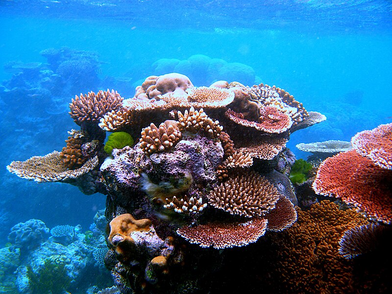
A variety of corals form an outcrop on Flynn Reef, part of the Great Barrier Reef near Cairns. Photo: Toby Hudson/Wikimedia Commons
Original story by AAP at The Australian
Less than two weeks out from the federal election, the environmentalists say they want urgent, effective government action to protect the reef from industrial port expansion.
Among those at the Rally for the Reef was a 72-year-old Brisbane woman who walked 1200km to ensure her great grandchildren will have the opportunity to experience the national wonder when they grow up.
June Norman said she completed the 80-day walk from Cairns to Gladstone and attended the rally on Sunday morning in an effort to highlight the threats that mining placed on the reef.
Her main concern is the sheer number of coal freighters travelling to and from ports via the reef.
"There is an average of one an hour, 24 hours a day, seven days a week," she said.
"Our fragile reef is not able to sustain this.
"Then you add the building of coal ports, the construction of train lines to the ports, dredging and the dumping of sludge out onto the reef."
Great Barrier Reef campaign director from the Australian Marine Conservation Society Felicity Wishart said the fast tracking of industrial development along the reef coastline was the largest emerging threat to the national treasure.
"During the election campaign, we've had promises from both major political parties that they will do all they can for the reef. But empty platitudes won't save the reef from port expansions," she said.
Ms Wishart claimed 4000 people turned out at the rally, showing that Australians wanted swift action taken to protect the Great Barrier Reef.